Auburn, Georgia
Auburn, Georgia | |
|---|---|
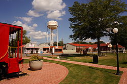
 Central Auburn in the city's historic district | |
| Motto: "Old southern charm with a vision for the future" | |
 Location in Barrow County and the state of Georgia | |
| Coordinates: 34°00′56″N 83°49′55″W / 34.01556°N 83.83194°W | |
| Country | United States |
| State | Georgia |
| Counties | Barrow, Gwinnett |
| Area | |
| • Total | 6.80 sq mi (17.61 km2) |
| • Land | 6.77 sq mi (17.54 km2) |
| • Water | 0.03 sq mi (0.07 km2) |
| Elevation | 1,024 ft (312 m) |
| Population (2020) | |
| • Total | 7,495 |
| • Density | 1,106.76/sq mi (427.30/km2) |
| Time zone | UTC-5 (Eastern (EST)) |
| • Summer (DST) | UTC-4 (EDT) |
| ZIP code | 30011 |
| Area code | 770 |
| FIPS code | 13-04140[3] |
| GNIS feature ID | 2403134[2] |
| Website | www |
Auburn is a city in Barrow and Gwinnett counties in the U.S. state of Georgia. As of the 2020 census, the city had a population of 7,495.
History
[edit]Auburn incorporated in 1892 soon after the railroad was extended to that point.[4]
Geography
[edit]Auburn is located in western Barrow County and is 42 miles (68 km) northeast of downtown Atlanta and 27 miles (43 km) west of Athens.
According to the United States Census Bureau, the town has a total area of 6.5 square miles (16.8 km2), of which 6.4 square miles (16.7 km2) is land and 0.03 square miles (0.07 km2), or 0.39%, is water.[3]
Demographics
[edit]| Census | Pop. | Note | %± |
|---|---|---|---|
| 1900 | 161 | — | |
| 1910 | 217 | 34.8% | |
| 1920 | 290 | 33.6% | |
| 1930 | 230 | −20.7% | |
| 1940 | 286 | 24.3% | |
| 1950 | 301 | 5.2% | |
| 1960 | 374 | 24.3% | |
| 1970 | 361 | −3.5% | |
| 1980 | 692 | 91.7% | |
| 1990 | 3,139 | 353.6% | |
| 2000 | 6,904 | 119.9% | |
| 2010 | 6,887 | −0.2% | |
| 2020 | 7,495 | 8.8% | |
| 2023 (est.) | 9,688 | [5] | 29.3% |
| U.S. Decennial Census[6] | |||
| Race | Num. | Perc. |
|---|---|---|
| White (non-Hispanic) | 5,325 | 71.05% |
| Black or African American (non-Hispanic) | 493 | 6.58% |
| Native American | 14 | 0.19% |
| Asian | 307 | 4.1% |
| Pacific Islander | 3 | 0.04% |
| Other/Mixed | 420 | 5.6% |
| Hispanic or Latino | 933 | 12.45% |
As of the 2020 United States census, there were 7,495 people, 2,436 households, and 1,849 families residing in the city.
As of 2022, 6,678 people in Auburn lived in Barrow County while 209 people lived in Gwinnett County.[8]
Education
[edit]The portion in Barrow County is in Barrow County Schools.[9] The Barrow district operates Auburn Elementary School, which feeds into Westside Middle School and Apalachee High School.[10][11]
The portion in Gwinnett County is in Gwinnett County Public Schools.[12] That portion's zoned schools are Mulberry Elementary School, Dacula Middle School, and Dacula High School.[13]
References
[edit]- ^ "2020 U.S. Gazetteer Files". United States Census Bureau. Retrieved December 18, 2021.
- ^ a b U.S. Geological Survey Geographic Names Information System: Auburn, Georgia
- ^ a b "Geographic Identifiers: 2010 Demographic Profile Data (G001): Auburn city, Georgia". American Factfinder. U.S. Census Bureau. Archived from the original on February 12, 2020. Retrieved November 29, 2016.
- ^ "History of Auburn". City of Auburn, GA. Retrieved April 1, 2018.
- ^ "City and Town Population Totals: 2020-2023". United States Census Bureau. May 16, 2024. Retrieved May 16, 2024.
- ^ "Census of Population and Housing". Census.gov. Retrieved June 4, 2015.
- ^ "Explore Census Data". data.census.gov. Retrieved December 12, 2021.
- ^ "General Highway Map Barrow County Georgia" (PDF). Georgia Department of Transportation. 2022. Retrieved September 24, 2024.
- ^ "2020 CENSUS - SCHOOL DISTRICT REFERENCE MAP: Barrow County, GA" (PDF). U.S. Census Bureau. Retrieved September 6, 2024. - Text list
- ^ "AHS Cluster Rezoning Recommendation Approved". Barrow County Schools. February 7, 2023. Retrieved September 6, 2024.
- ^ "BCSS Attendance Zone Maps". Barrow County Schools. Retrieved September 6, 2024.
- ^ "2020 CENSUS - SCHOOL DISTRICT REFERENCE MAP: Gwinnett County, GA" (PDF). U.S. Census Bureau. Retrieved September 6, 2024. - Text list
- ^ "Dacula Cluster 2024-2025". Gwinnett County Public Schools. Retrieved September 7, 2024.


